
3D Cloud Geometry Simulator
Controlled simulator of 3D cloud scenes, generating synthetic satellite and ground-camera views to validate voxel-based reconstruction, cloud localization, and shadow prediction for solar forecasting.
MATLAB combines numerical computing, algorithm development and scientific visualization in an engineering-oriented environment. It is particularly useful for prototyping signal-processing methods, reconstructing physical phenomena and producing diagnostic visualizations that can be reviewed with domain experts.

Forecasting and analytical models developed, evaluated, deployed, and monitored for operational use.
Extracting insights and building predictive models from data using statistics, machine learning, and programming
Reliable metrics and analytical tools for monitoring performance, investigating issues, and supporting decisions.
Applies rigorous scientific methods to explore, test, and validate data-driven ideas.
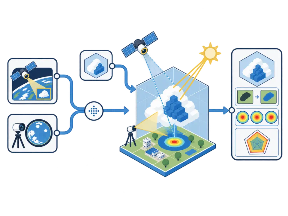
Clouds are represented as simple 3D volumes made of small cubes (voxels). This allows the creation of realistic scenes, from scattered cumulus to uniform stratus layers.
Each virtual cloud scene is viewed simultaneously by a simulated satellite and ground camera. The result is a pair of synthetic images that mimic real observations with controlled conditions.
Cloud pixels detected in each image are projected into 3D space based on the geometry of both sensors.
The overlap between satellite and ground projections reveals the most probable cloud positions in three dimensions.
The simulator compares the reconstructed clouds with their true positions to measure spatial precision.
It also checks how accurately the estimated cloud shadows align with the true ones on the ground.
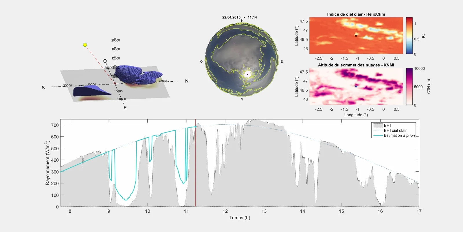
Clouds observed from the ground and from space are projected into the same 3D volume. Combining both viewpoints provides estimates of cloud position and height, which are then used to calculate shadow paths and surface irradiance.
Cloud motion vectors are calculated from successive images and extrapolated to forecast cloud displacement and irradiance variations over the next 10 to 15 minutes. The objective is to anticipate rapid changes in photovoltaic production caused by moving clouds.
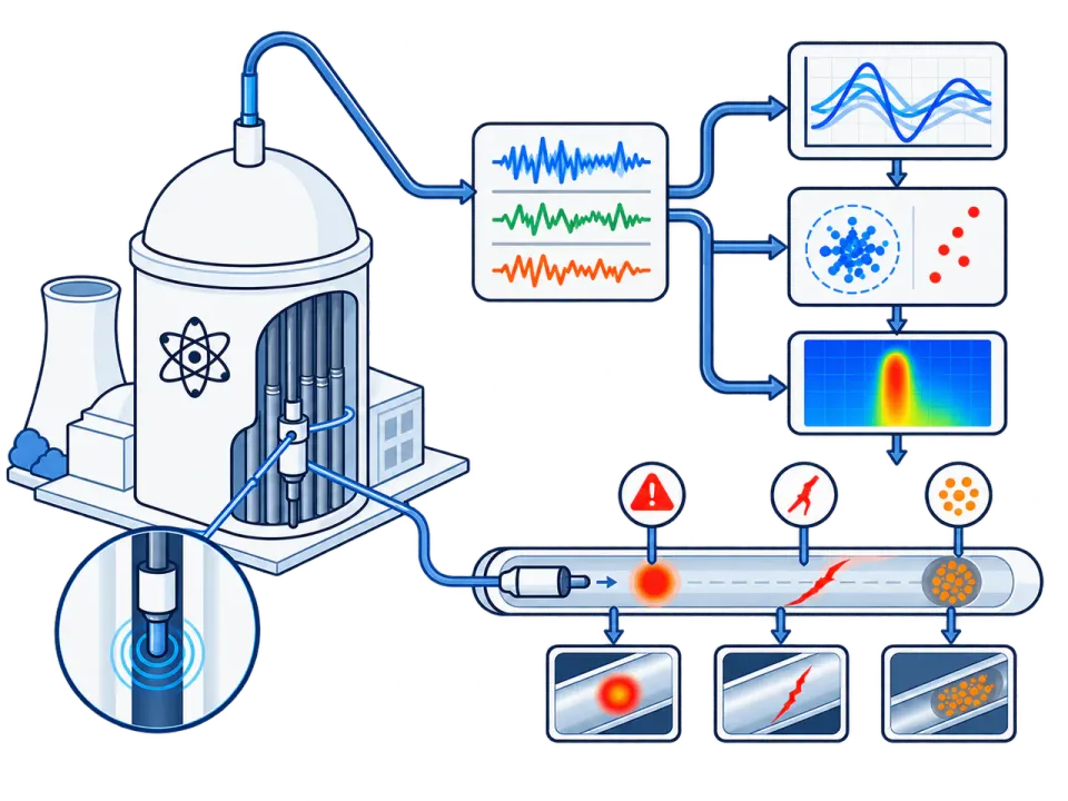
Periodic inspections of steam-generator tubes were analyzed using axial eddy-current (SAX) measurements acquired at tube/support-plate intersections.
The project focused on interpreting the electromagnetic response of the inspection signals in order to assess the presence of deposits affecting support-plate passages.
Developed MATLAB tools for preprocessing, denoising, signal alignment, and deconvolution of complex eddy-current signals.
The work built on EDF’s IComplexe approach and focused on extracting signal features that could support engineering assessment of clogging.
Implemented analysis and visualization tools used to review processed signals and support interpretation by engineers.
Results were compared with available inspection references, including visual examination data, in order to support the evaluation of clogging profiles.

Controlled simulator of 3D cloud scenes, generating synthetic satellite and ground-camera views to validate voxel-based reconstruction, cloud localization, and shadow prediction for solar forecasting.

Fusion of hemispheric sky-camera and geostationary satellite data to reconstruct clouds in 3D, estimate their shadows on the ground, and improve very-short-term solar irradiance forecasting.

Processing and deconvolution of SAX eddy-current signals to help engineers assess steam-generator support-plate clogging during periodic inspections.